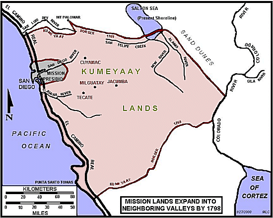
KUMEYAAY LANDS MAP 1798 Spanish Mission Expansion San Diego
This Mike Connolly Miskwish, Campo-Kumeyaay website historical map "Mission Lands Expand Into Neighboring Valleys by 1798" photo details the Kumeyaay Nation ancestral tribal lands and the expansion of the Spanish Mission Presidio in San Diego, California, 1798.
Kosa'aay Kumeyaay village
GROUND ZERO for the California Indigenous Tribes:

KUMEYAAY MAPPING PROJECT: Historic present-day area of Kosa'aay pictured in 2026, now known as Old Town San Diego, a popular tourist hotspot celebrating Colonial history:KUMEYAAY MAPPING PROJECT:
- Presideo Park (presideo translates to military fort),
- Junipero Serra Museum (honors the priest who founded Mission San Diego de Alcalá in 1769 near Kosa'aay",
- Whaley House Museum and Old Town San Diego State Historic Park (American period).
But nothing dedicated to the period Indigenous peoples, why?

HOW DID THE ABORIGINAL TRIBESMEN APPEAR Back in the Day?
I can imagine this is how the 16th and 18th century tribesmen appeared on the shorelines and villages of "Discovery" 1542, and "Invasion" (1760s):
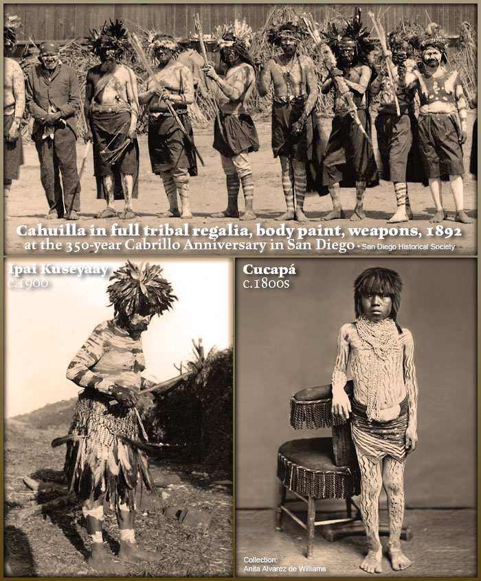
Notice their full body, chest, face and leg paint, feathered headdresses, bandannas, lances, painted bows -- this is what authentic San Diego area male tribal regalia looks like... San Diego Indigenous CULTURE.
Paul Campbell captioned the old 19th century studio photo:
Painted Cocopa child. Note the design that results from scraping paint away with fingernails. Very old photograph. (From collection of Anita Alvarez de Williams.)

This historical map graphic is being used by the Kumeyaay Information Village website in its Kumeyaay History online sections.

Visit Mike Connolly's Kumeyaay band in the Smithsonian.
Five more MIKE CONNOLLY MISKWISH Campo Maps may be accessed here.
These five historical Kumeyaay maps detail Kumeyaay points of history:
• The arrival of the Spanish in San Diego 1769
• The Spanish expansion into Kumeyaay Indigenous tribal territory 1798
• The maximum extent of Spanish control in San Diego 1822
• The Kumeyaay attacks on the Spanish to regain their lands 1836-1842
• The Treaty of Santa Ysabel 1852
Click on Kumeyaay map thumbnails for higher resolution copy.
These five maps detail Kumeyaay points of history, the arrival of the Spanish 1769, the Spanish expansion into Kumeyaay Indigenous territory 1798, the maximum extent of Spanish control 1822, the Kumeyaay attacks on the Spanish to regain their lands 1836-1842, the Treaty of Santa Ysabel 1852.
|